Thanks Lovell!
And then we headed up to the Bighorn Canyon National Recreation Area. I had never heard of this place before, which is kind of surprising. When you see the photos, you'll understand why we are surprised that it's not more popular.
It is fairly popular with boaters though. There are two boat launch ramps that go down to the water and then you can boat through the canyon. That would be a fun boat trip!

Scenery along the way.
The first thing we learned is that there is no boondocking (free camping) within Bighorn Canyon, which is too bad. They have two different campgrounds without hookups and they are $15 USD ($20.25 CAD) per night. There is also a wildlife management area that has free camping just before you enter Bighorn Canyon, but it's not nearly as scenic.

Almost there.


This is the day use area at Bighorn Lake, the southern part of the park.

Like I said, quite a few boaters here, and they have all the toys.


Lots of rock formations.
But the best is yet to come!


Sherman.
Notice the empty parking area?

Scenery along the way.

Not the best photo.
I think the one lying down is pregnant!
There is a herd of wild horses that live in part of the canyon. They estimate there are between 90 and 120 of them.

Devil's Canyon Overlook.
There were a couple of other cars here.


There are some great views from this stop!


And this is where the best view is!
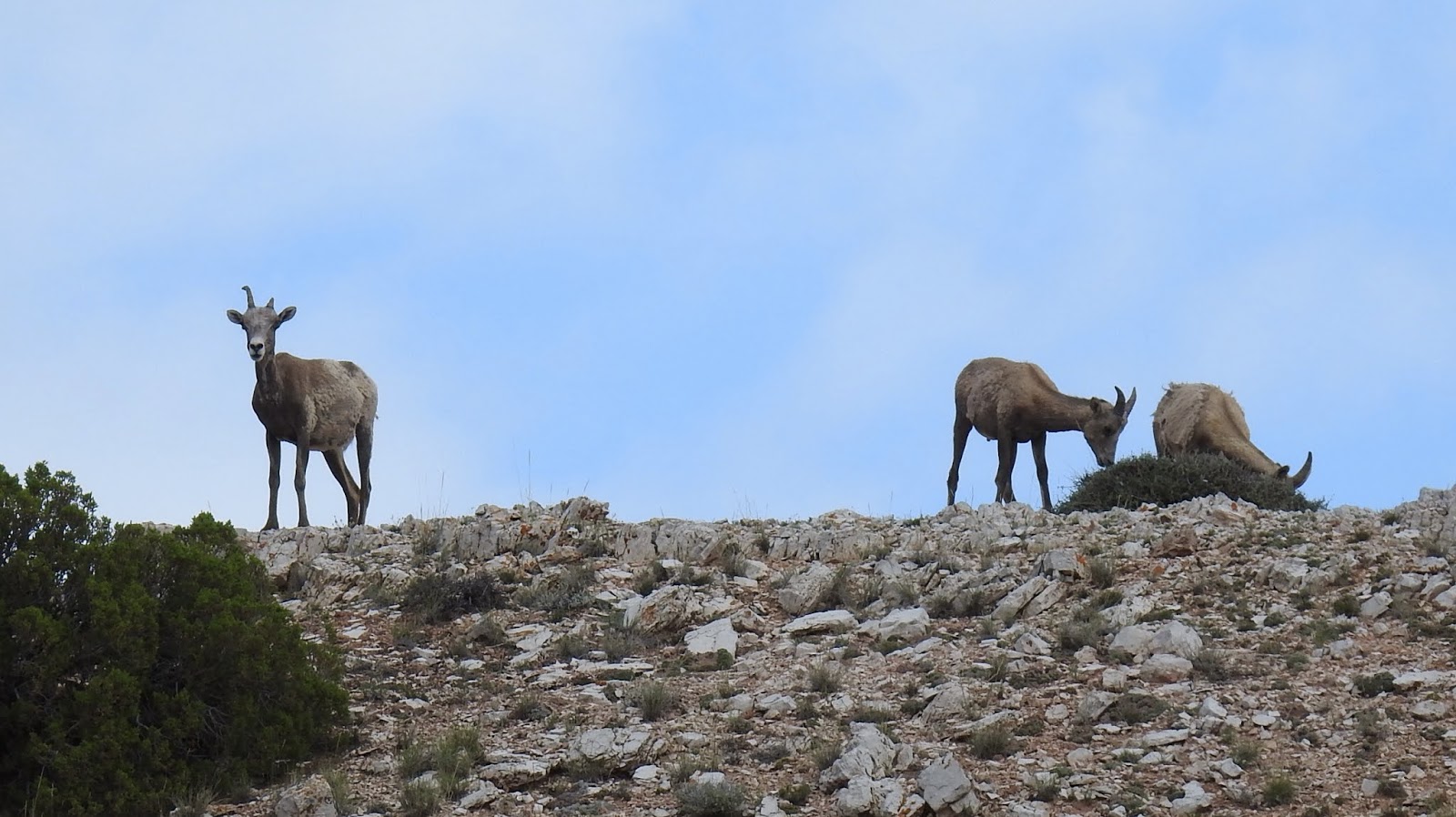

At the beginning of the trail we saw some bighorn sheep.

Here's Ruth, enjoying the views!

And me!

Looking left.

And looking right.
Wow!

A violet-green swallow.

Sherman with the parking lot to himself.
We carried on to the furthest parking area that is still on the paved road. There is another campground and another boat launch area. Pretty busy at this spot, but mostly with boaters.


More scenery along the way.

Nice weather for boating.
There were a couple of trails we wouldn't have minded doing, but it was a hot afternoon... high was about 90F (32C) and the sun was hot.

The boat launch is a long steep road down with nowhere to turn around. I think the boaters have to back all the way down here!

It's a pretty spot.
That was the point where we decided to head back. Surprisingly, the campgrounds still had availability, but we would rather find a free spot away from everybody and not pay the $15. So we decided to leave the park and head about another 25 miles (40 kms) to the Bighorn National Forest which means driving up a VERY steep (but nicely paved) road to get to some higher altitude and fresher air.

As we left, Ruth spotted the big birds nest in a hole in the side of this cliff.
Can you see it?
Let me zoom in for you...

Two young red tailed hawks.

We stopped in at a historic ranch property.
This was the schoolhouse!

Sherman. Again with an empty parking lot.
Although, as we were leaving three other vehicles were pulling in.

More bighorn sheep.

This is a healthy looking fellow.

We are headed up there!
Like I said, the road is steep. There are signs at the beginning warning of the "steep grades ahead". This is highway 14A that runs across northern Wyoming. One section gains 6,000' (1,800 meters) in about 24 miles (40 kms). And, remember that it's a hot day... 90F (32C).
Well, Sherman's temperature gauge was getting a little on the high side. We stopped at the side of the road at one point to let things cool down for an hour. But even then, the engine was still at around normal operating temperature when we set off again, so another couple of miles up it was time to pull over again.
This time (with another 3,500' still left to climb) we decided to call it a day and found ourselves a nice lookoff spot to spend the night. Fortunately, there is hardly any traffic. We'll get up at 6:00am and do the rest of the climb when it's quite a bit cooler out.

Sherman's spot for the night.
You can see where the road climbs up behind us.

We have some nice views!

When I went out for a walk to take these photos, I came across an odd hole in the ground. It was perfectly round, about 3 feet across and about 3 feet deep. Nothing growing inside, and yet you tell it wasn't fresh. Very strange.

Strange hole in the ground.

More views.

An interesting hill in the distance.

Another view.

Sherman.

Sherman.
Just before sunset, this big male pronghorn ran across the front of where we are parked. He was a big guy...

Big male pronghorn.
Not sure where we will end up today, but the first thing we have to do is to climb a really steep hill. Hopefully Sherman is up to the challenge.
--------------------------------------------------------------------------------------------------------------------------
Stainless Steel Measuring Cups and Spoons. Built to last a lifetime.
And in Canada...
You're in some of our favorite areas from our trip last year. Had hoped to do it this year but maybe not until September.
ReplyDeleteWe can certainly see why this is some of your favorite areas, it really is beautiful up in this part of the country. We sure hope that you will be able to do the trip in September, I am sure that would still be a great visit the area.
DeleteBoy, Ruth sure has sharp eyes spotting the Red Tail Hawk nest. The Pronghorn it beautiful
ReplyDeleteThank you Garth but the only reason I happened to notice the nest and the birds was that I saw movement up there. Not sure if the mom had just flown out or just that one of the little ones was moving around but that is what caught my eye so I made Kevin pullover and got the camera and binoculars out. :-)
DeleteWe did that 14A climb back in 1976 pulling a 25-foot travel travel. Our first trip pulling a trailer. Scary!
ReplyDeleteYep, that was a hard climb for sure and if it was your first time pulling a trailer, then yep it would have been a little nerve racking. It was definitely one of Sherman's more difficult climbs.
DeleteI forgot to say, great photos.
ReplyDeleteThank you! :-)
DeleteBeautiful Pictures. We were pulling our Avalache through that area in 2012 and had to let our Truck cool down. Can imagine how Sherman is struggling.
ReplyDeleteBe Safe and Enjoy the area.
It's about time.
Sherman really only struggled on one small really steep section otherwise he probably would have been totally fine if we had started the climb in the morning with a totally cold engine. It was definitely one of Sherman's most difficult climbs.
DeleteWhen the engine needs to cool down, do you raise the hood so heat can escape faster? It helps.
ReplyDeleteNo, because Sherman's engine compartment is inside of the motorhome between the drive's seat and the passenger's seat and it would have just heated up the inside of the motorhome even more than it already was, plus the "cooler" air outside wouldn't have been able to get at it because of the engine being inside.
DeleteEnjoying the pictures from Big Horn and Bear Tooth Pass. We love the drive on 14A too.
ReplyDeleteDavy
So glad that you have been enjoying our pictures. It really is a fantastic place to explore. I wish we had more time because there was so much to do in the area. Looks like we will just have to return again someday.
DeleteGlad you did make it to the Bighorn Canyon NRA! It was stunning, and with our 1/2 price park pass (since Barry was 62), we didn't mind one bit paying for camping. We did several bike rides while we were there, including one all the way to the end, where you drove, and that as some CHALLENGING cycling with the hills. But you're right, the views are stupendous. I hope we can get back there one day! Here's our blog post about our epic bike ride -- you'll recognize the sights along the way: https://travelingtwosome.weebly.com/traveling-twosome-blog/bighorn-canyon-bicycling-the-canyon-road. We have to get back someday, but I hope to have an e-bike by then. The hills do not get easier as you get older, that's for sure!
ReplyDeleteWow, what a ride you had. I remember doing those hills in Sherman and a couple of them were quite steep, good for you guys doing it on a bike. We liked Devil's Canyon Lookoff but personally enjoyed the view from the hike we did that was about a mile further along down the road. There is no mention of if on the sign post, only a sign for parking. The hike was about a mile long in total and nobody on it and some fantastic views of the canyon.
Delete